A guide on how you can get to Alcatraz Island

Where is Alcatraz located

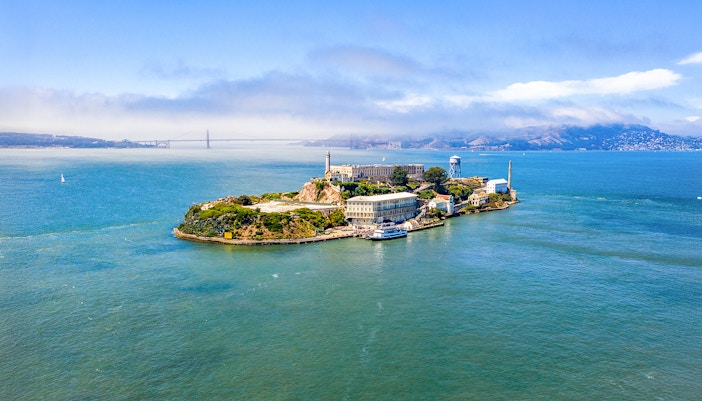
Alcatraz Island is located 1.25 miles offshore in the middle of San Francisco Bay. While the island itself is only accessible by boat, reaching the departure point—Pier 33 Alcatraz Landing—is easy from anywhere in the city. Here’s everything you need to know to get there smoothly.

Address: Pier 33, The Embarcadero, San Francisco, CA 94133, USA

Find on Maps

Did you know? The pier is not just a transportation hub; it’s the beginning of the Alcatraz experience, offering exhibits, ticketing facilities, and orientation before you board the ferry.

How to reach Pier 33 by public transportation

Man enjoying a bus ride, part of the "Getting there" tour experience.

MUNI Buses

  • Travel time: 15–30 minutes (depending on the route)
  • Cost: $3 per ride, free for kids under 4
  • Routes: Bus 8, 30, 39, and 47
  • Nearest stop: North Point St & The Embarcadero or Kearny St & North Point
  • Directions: From either stop, walk 5–7 minutes along the waterfront to Pier 33
  • Tip: Use Google Maps or the MuniMobile app for real-time bus arrivals and quickest transfers.
Streetcar on Market Street in San Francisco with city buildings in the background.

F-Line Historic Streetcar

  • Travel time: 15–25 minutes (from Market St/Union Square)
  • Cost: $3 per ride (Muni fare)
  • Boarding point: Any F-line stop along Market Street or The Embarcadero
  • Nearest stop: Bay St & The Embarcadero, both are directly across from Pier 33
  • Directions: Once off the streetcar, just cross the road and follow the signs for Alcatraz Cruises
  • Note: This vintage streetcar is both a mode of transport and a sightseeing experience in itself—great bay views, colorful historic cars, and lots of photo ops.
Bay Area Rapid Transit train on tracks surrounded by trees and construction cones.

BART (Bay Area Rapid Transit)

  • Travel time: 10–30 minutes (from central SF); ~40 minutes from SFO
  • Cost: $2–$10, depending on distance (use a Clipper card or purchase a paper ticket)
  • Boarding point: Any BART station (e.g., Civic Center, Powell, Montgomery, or Embarcadero)
  • Nearest stop: Embarcadero Station
  • Directions: Exit at Embarcadero, walk ~25 minutes along the waterfront, or transfer to the F-Line Streetcar for a quicker ride to Pier 33
  • Tip: If you're short on time, use rideshare for the last leg from Embarcadero BART to the pier.

Reach Pier 33 by car

Couple smiling while driving on a road trip from Rome to Naples.

Driving route

Distance covered: 2.2 miles
Travel time: 12–18 minutes, depending on traffic along The Embarcadero.

From Union Square (Downtown SF)

  • Exit Union Square by heading east on Geary Street for about 0.3 miles.
  • Turn left onto Stockton Street and continue through the Stockton Tunnel for 0.4 miles.
  • After exiting the tunnel, turn right onto Clay Street and drive downhill for about 0.6 miles toward the waterfront.
  • Turn left onto The Embarcadero and continue north for approximately 0.8 miles.
  • Look for Pier 33 Alcatraz Landing on your right side.
Underground parking garage with multiple cars and orange P1 D signs.

Nearby parking facilities

Street parking around Pier 33 is scarce and often limited—most meters cap at 2 hours and cost around $2–$3.50/hour. Several nearby garages offer all-day parking in the $8–$10 range, with options that may reach $20–$30/day.

Popular choices include:

Reach Pier 33 on foot

Woman walking on a hilly street in San Francisco with cityscape in background.

Walking to Pier 33 is scenic and easy, especially from Fisherman’s Wharf, North Beach, or the Financial District (10–25 mins).

  • From Fisherman’s Wharf: Pass seafood shacks and enjoy Golden Gate views. Nearby highlights include Pier 39 with its sea lions and the Aquarium of the Bay.
  • From North Beach: Stroll past murals, cafés, and Italian charm. You’ll also be close to Coit Tower for panoramic views.
  • From the Financial District: Walk along the palm-lined Embarcadero with Ferry Building Marketplace and Bay Bridge views. Just beyond, you’ll find the Exploratorium for hands-on science fun.

Explore nearby: The San Francisco Museum of Modern Art (SFMOMA) and California Academy of Sciences are a bit farther but pair well with an Alcatraz day trip if you’re building a full itinerary.

Tip: Great for casual strollers—expect flat paths, waterfront breezes, and plenty of spots to pause for photos or coffee.

Frequently asked questions about getting to Alcatraz Island

Is Pier 33 the only place to board the Alcatraz ferry?

Yes. All official ferries to Alcatraz Island depart exclusively from Pier 33 Alcatraz Landing. There are no alternative boarding points.

Is public transportation reliable to get to Pier 33?

Absolutely. Between Muni buses, the F-line streetcar, and nearby BART stations, public transit offers easy and affordable access to the pier.

Is the pier wheelchair-accessible?

Yes. Pier 33, the boarding area, and the ferry itself are all fully wheelchair-accessible. There are also accessible restrooms and assistance available on-site.

Can I drive to Alcatraz Island?

No. The island is only accessible by ferry. However, you can drive to Pier 33, park nearby in public garages, and board from there.

What are the peak traffic hours around Pier 33?

Expect heavier traffic between 7:30–9:30am and 4–6:30pm on weekdays. On weekends and holidays, the area can stay busy most of the day due to tourist footfall.

More reads

Aerial view of Alcatraz Island with San Francisco Bay in the background.

About

Broadway corridor between B and C Blocks in Alcatraz Prison.

History

Guests photographing sunset near Alcatraz Island during California Sunset cruise.

Plan your visit